A 10-year plan for a metropolitan city making 10,000 km of sideways accessible
- Solution
- Accessibility Comprehensive Plan for Urban Spaces in Tehran
- Country of Implementation
- Iran
- Start Year
- 2019
- First published
- 03.12.2023
Solution details
People
Mani RAZAVIZADEH
“This inclusive model enables the enhancement of accessibility in Tehran, the capital of Iran, with a population of over 10 million.” Hamid Fathi, Project Manager, Omran Zaveh Engineering Consultants Co.
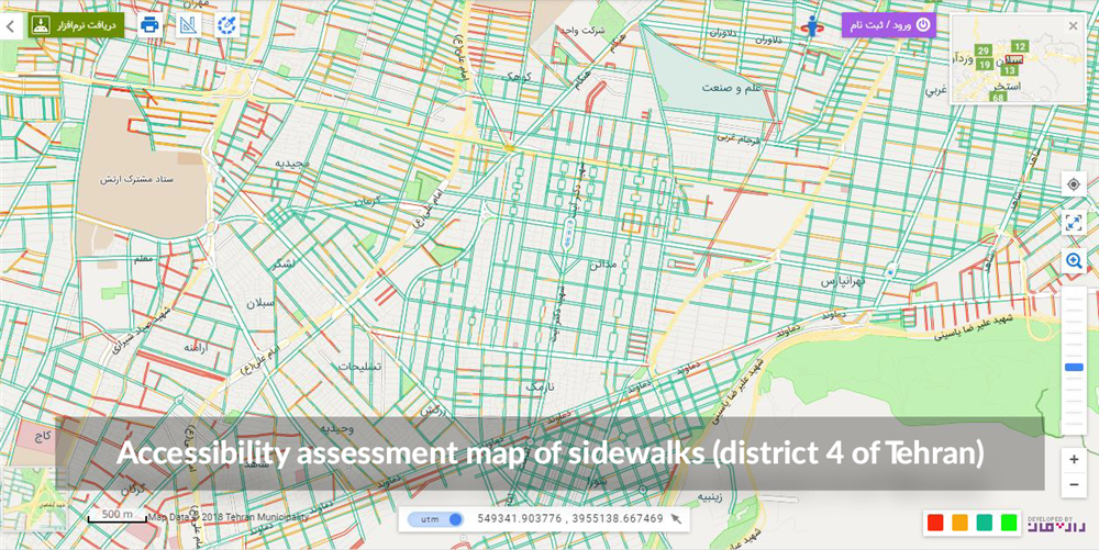
The Accessibility Comprehensive Plan for Urban Spaces in Tehran project started in 2019 and is operated by Omran Zaveh Engineering Consultants Co., a company based in Iran. It focuses on identifying, categorizing, and prioritizing accessible routes, assessing sidewalk accessibility, and developing an action plan to improve sidewalks and public places. The project’s output is available through an online map provided by Tehran Municipality. By 2023, 10 per cent of the metropolitan area’s accessibility implementation has been completed.
Problems Targeted
The lack of reliable information on Tehran’s sidewalk accessibility often poses challenges for people with disabilities and the elderly.
Solution, Innovation and Impact
The Accessibility Comprehensive Plan for Urban Spaces in Tehran is based on a 2019 contract between the Accessibility Headquarters of Tehran Municipality and the Omran Zaveh Engineering Consultants Co., a company based in Tehran, which runs the operations. Tehran is a city of more than 10 million inhabitants. To begin, the main roads were categorized into priorities and then further divided into three phases regarding the implementation of the improvements. As part of the plan, an average of 480 km of sidewalks will be constructed and 127 km will be repaired annually. The plan introduced a web-based application for continuous data collection and analysis. It uses a method called MCDM (Multi-Criteria Decision Analysis) to understand and plan the best routes in the city. To visualize this data, a GIS-based platform helps to display and analyse information on maps. After having evaluated all Tehran’s sidewalks with a width of more than 12 metres, the plan’s output is an online map that allows persons with disabilities to view the accessibility of pedestrian routes. As of mid-2023 the plan had covered approximately 1,000 kilometres out of the total 10,000 kilometres of the project (10 per cent), distributed across all 22 districts of the city.
Funding, Outlook and Transferability
The project received funding from Tehran Municipality’s general budget after city council approval. The Accessibility Action Plan, a 10-year programme starting in 2021, aims to construct and repair sidewalks annually, with regular reviews for effectiveness. All results of improvements are publicly available. (Awardee 2024)
Media
Pictures
Related information
- Connections
- 1
-
People
